• Skip to primary navigation
  • Skip to main content

CINA.

  • About
    • Mission
    • People
  • Research
    • Research
    • Projects
    • RFPs
  • Education
    • Resources
    • Internships
  • Publications
    • Newsletter Archive
    • Director’s Blog
  • News & Events
    • News
    • CINA Director’s Blog
    • Digital Archive
    • Events
    • Work with Us
  • Contact
  • Search Toggle
  • Skip to content

A critical review of high and very high-resolution remote sensing approaches for detecting and mapping slums: Trends, challenges and emerging opportunities.

Jan 2018

  • Journal Article

Urban Science
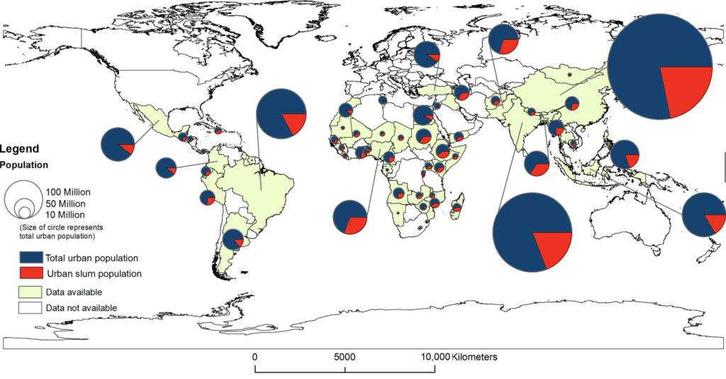
Slums are a global urban challenge, with less developed countries being particularly impacted. To adequately detect and map them, data is needed on their location, spatial extent and evolution. High- and very high-resolution remote sensing imagery has emerged as an important source of data in this regard. The purpose of this paper is to critically review studies that have used such data to detect and map slums. Our analysis shows that while such studies have been increasing over time, they tend to be concentrated to a few geographical areas and often focus on the use of a single approach (e.g., image texture and object-based image analysis), thus limiting generalizability to understand slums, their population, and evolution within the global context. We argue that to develop a more comprehensive framework that can be used to detect and map slums, other emerging sourcing of geospatial data should be considered (e.g., volunteer geographic information) in conjunction with growing trends and advancements in technology (e.g., geosensor networks). Through such data integration and analysis we can then create a benchmark for determining the most suitable methods for mapping slums in a given locality, thus fostering the creation of new approaches to address this challenge.

Citation:

Mahabir, R., Croitoru, A., Crooks, A., Agouris, P., & Stefanidis, A. (2018). A critical review of high and very high-resolution remote sensing approaches for detecting and mapping slums: Trends, challenges and emerging opportunities. Urban Science, 2(1), 8.

Authors

  • Anthony Stefanidis
  • Ron Mahabir
  • Arie Croitoru
  • Andrew Crooks
  • Peggy Agouris
Publication Download

Topics:

  • Geospatial
  • Open source data

Research Areas:

  • Spatiotemporal patterns

*The programs and services offered by George Mason University are open to all who seek them. George Mason does not discriminate on the basis of race, color, religion, ethnic national origin (including shared ancestry and/or ethnic characteristics), sex, disability, military status (including veteran status), sexual orientation, gender identity, gender expression, age, marital status, pregnancy status, genetic information, or any other characteristic protected by law. After an initial review of its policies and practices, the university affirms its commitment to meet all federal mandates as articulated in federal law, as well as recent executive orders and federal agency directives.

CINA Now

Events

All Events

Publications

The Key to Deobfuscation is Pattern of Life, not Overcoming Encryption

Published: Oct 4, 2025

The Organized Activities of Ransomware Groups: A Social network Approach

Published: Mar 14, 2025
All Publications

News

CINA Distinguished Speaker Series with Colton Seale: Interviewer Mindset

CINA  |   April 3, 2025  |   Posted In:
  • Digital Archive
  • Uncategorized

CINA  |   March 6, 2025  |   Posted In:
  • Uncategorized
All News

Science and Technology Directorate’s Office of University Programs
CINA at George Mason University Logo
Copyright © 2025 All Rights Reserved | CINA Is A Department of Homeland Security Center of Excellence led by George Mason University
  • Facebook
  • Twitter
  • Instagram
  • Linkedin
  • YouTube